Sunday morning dawned no better than the day before. The rain had thundered on the metal roof all night,so we were not too hopeful about the day's riding ahead. In fact, after breakfast, 5 of us (half of the group) rebelled and decided we'd ride in the van in hopes that it would clear up enough to ride later. Nearly 30 km into the ride, it did clear up and most of us were suckered into getting down the bikes, gearing up and getting ready to go. So it promptly started to rain again. Sigh. Well, we were committed now (or should have been, perhaps), so we soldiered on the 15 km or so to lunch in the town of Franz Joseph Glacier. Too much lunch for so little riding, and then we were off into yet another shower. We had cut out mostly flat riding, and the terrain after lunch was to be three good climbs. Oh, too much lunch. It kept warming up (jacket off) then raining again (jacket on), and then warming up, and then raining again. Oy.
Just as on the day out of Westport, our guide (Alex this time) claimed we were at the top of the second climb when it was really the top of the first. Do they really think we can't count? Is this their idea of encouragement? Can't
they count? Well, they're nice guys, so we won't hold it against them.
The last climb was the shortest, but also the steepest, plus a couple of cattle guards (or cattle stops, as they call them). One more really good descent (only it was raining, get the picture?), and we rode into Fox Glacier and our hotel. More stripping off of wet clothes and carrying bikes through to the patio where they could drip off under the overhang.
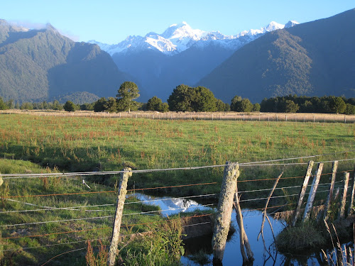
By dinnertime, however, things had cleared up, and we were rewarded by seeing the Southern Alps at last.

And, after dinner, by seeing some keas -- the large parrots native to the south island that are famous for chewing rubber. Like bike seats and handlebar tape. I went straight back to the hotel and covered my saddle with a Bike to Work Day musette.

Today was a rest day, so we took a half-day glacier walk (you're actually on the glacier for only about an hour, but it takes the rest of the time to gear up with boots and crampons, drive up there, and hike up to the glacier terminus, plus everything in reverse after. The glacier forms from the 30 to 60 meters (!) of snow that falls at the neve (the top, where the glacier forms). And it takes 50-60 years for what fell up there to reach the terminus. This is a view as we hiked up the moraine towards the terminus. The bluish water is glacial melt that's had time to settle. In this case, it's the melt from the carpark, which is on top of a large chunk of the glacier that broke off in about 1960 and then was covered by a rock fall, which insulated it from its normal melting rate. Every year, the carpark subsides about a meter and they have to repave it.

And hiked a bit further, crossing a stream that had been diverted a couple of days ago when the heavy rains (that we were riding in) caused a flash flood, bringing down a bunch of rock.

When we had almost reached the terminus, we put on our insole crampons.

Just as we finsihed putting on our crampons, we heard a loud roar and turned around just in time to see the last bits off ice fall from where a chunk of the glacial face had broken off and crashed to the ground below (the clean-looking little pile of snow at the bottom of the face below).
Once on the ice, we were instructed to follow in a single line behind our guide and to keep back a little distance from his swinging ice axe (he was reforming the stairs cut in the ice in places where they had melted enough to become dangerous). Straying off from his path risks falling into a sinkhole or coming too close to an edge that is ready to break off.
Our guide, Dean, explained how glacial moulins got their name. Some Frenchman thought they looked like the fixed stone funnel part of a grain mill. Not sure I'd agree, but at least I'll be able to remember what they're called. They are basically a place where the glacial melt stops flowing on top of the ice and instead forms a sort of waterfall as it drops through the ice and flows inside or under the glacier. This is one end (the lower end)...

And this is the other (upper) end of one.
And this was a really cool one that he had been watching develop for several days. It must be fun to come out onto the glacier often enough to see these changes happening.

This picture shows the path we climbed up and down to get on and off the face of the glacier. The two men are standing just to the left of it, and you can see that the drop-off to the right of it is getting kind of close to it. In a day or two, it will be too dangerous to walk there, so the guy farther to the left of the picture is starting to hack a new path.
After returning to town and doing our laundry, we rode out to Lake Matheson (about 5 km). This is supposed to be the iconic New Zealand picture, but you have to get there early in the morning when the lake is still and the clouds haven't formed from the warm air rising up the mountains. Still pretty darn gorgeous. There was another wonderful rainforest walk around the lake, and we took too many pictures, but it's getting late, and I need to go to bed.
We did see a couple of new birds. A number of fantails, but they moved too fast to let us take a picture. And a kereru, or New Zealand pigeon. Lovely white bloomers, I must say.
And, finally, dinner at the Lake Matheson Cafe. Decidedly a "posh nosh" as the reviews had promised, and you can't beat the view. As the evening wore on and the clouds cleared, Mt. Cook (on the right) and Mt. Tasman (on the left) came into view. This picture was taken not from the restaurant, but about 1/2 a km away as we rode home.


This is my favorite set of pix so far, E. So glad the rain stopped. Hey:it just started here, finally.
ReplyDelete